|
|
Post by SiMoult on Dec 14, 2008 15:58:33 GMT
|
|
|
|
Post by mtbman on Dec 14, 2008 16:05:25 GMT
I'm lovin it  What phone is that on you flash git? |
|
|
|
Post by danevs on Dec 14, 2008 16:06:44 GMT
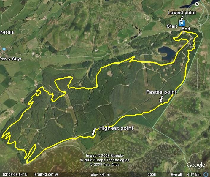
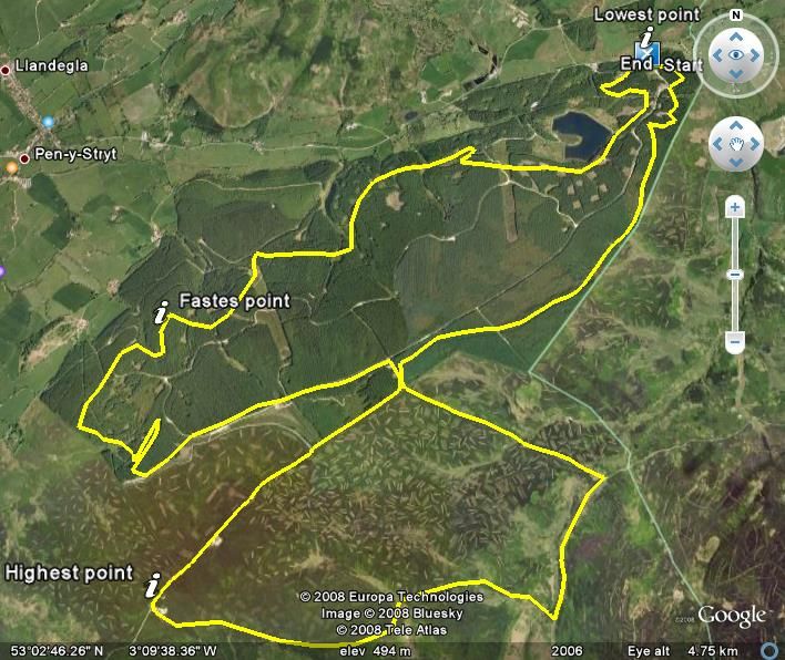
How exactly was your fastest point on the first map the climb? You're either a climbing sadist (Martin  ) or your brakes are jammed on.  Just looked at your ride times mate, impressive.  Have to get out for a blast together sometime.  |
|
|
|
Post by ninja penguin on Dec 14, 2008 16:30:44 GMT
That pretty impressive Si, you'll have to show me how to do it next time we're out - I still haven't worked it out  Those times aren't bad, did punk keep up alright? ;D |
|
|
|
Post by Ken on Dec 14, 2008 19:50:20 GMT
Impressive , just wondering do you put positions of photos on map or phone it self ? because it looks to me as if last two pics on Penmachno are taken at end of single track after highest point and not where shown on map. All the same still very impressived .
|
|
|
|
Post by SiMoult on Dec 14, 2008 21:12:27 GMT
I'm lovin it What phone is that on you flash git? Nokia N82 - as long as the phone has GPS you can do it on any Nokia - just download the program for free. Think Sony Ericsson have their own version too  |
|
|
|
Post by SiMoult on Dec 14, 2008 21:19:43 GMT
How exactly was your fastest point on the first map the climb? You're either a climbing sadist (Martin ) or your brakes are jammed on. Just looked at your ride times mate, impressive. Have to get out for a blast together sometime. Ah - sometimes the GPS signal gets lost so when it comes back it thinks you have got between 2 points extremely quick, hence the results sometimes can be a bit crazy ;D The times are always correct and so are the highest and lowest points tho Yeh must get out for a blast sometime - always good to ride with new people |
|
|
|
Post by SiMoult on Dec 14, 2008 21:24:47 GMT
Impressive , just wondering do you put positions of photos on map or phone it self ? because it looks to me as if last two pics on Penmachno are taken at end of single track after highest point and not where shown on map. All the same still very impressived . You can enable geo-tagging on the camera within the phone. So as long as you wait a few seconds for it to get the signal before you take the photo it will automatically tag the photos to the correct place on the map. Had a few issues with the technology to start off with but now 9 times out of 10 it pops them in the correct place. The only problem is with the GPS enabled it DRAINS the battery. About 2-3 hours and it's just about gone ;D Still a pretty cool novelty |
|
|
|
Post by SiMoult on Dec 14, 2008 22:07:08 GMT
That pretty impressive Si, you'll have to show me how to do it next time we're out - I still haven't worked it out Those times aren't bad, did punk keep up alright? ;D I will give you some pointers when we next meet up Gaz Punk was a little fitter those days ;D ;D ;D |
|
Rich
Rookie

Posts: 78
|
Post by Rich on Dec 15, 2008 1:28:49 GMT
Found the Marin Trail on the Nokia sportstracker website. sportstracker.nokia.com/nts/workoutdetail/index.do?id=269170Have a look around it, loads of cycle and walking routes, with the option of opening them in google earth Found this website www.gpsvisualizer.com/ aswell, for converting magellen, Garmin etc gps data to google earth Also found this little open source app that connects directly to your gps and converts stuff to a multitude of formats including google earth www.gpsbabel.org/It works great with my Garmin gps 60, take a look |
|
Rich
Rookie
Posts: 78
|
Post by Rich on Dec 16, 2008 12:30:44 GMT
Found this website, which has loads of trails on it, very simular to the nokia sportstracker but works with more gps enabled phones and gps devices www.sanoodi.com |
|
Caz
Have-a-go Hero
Posts: 224
|
Post by Caz on Dec 22, 2008 21:33:31 GMT
Cool images, Simoult
|
|
|
|
Post by Rob on Jan 9, 2009 21:32:08 GMT
Si,
Did you say the height in accurate?, i had a look at the Llandegla Black route but the height makes no sense, the highest point on your log is 575m is higher that the heighest point around Llandegla being Cyrn-y-Brain at 565m.
|
|
|
|
Post by SiMoult on Jan 10, 2009 22:55:19 GMT
Si, Did you say the height in accurate?, i had a look at the Llandegla Black route but the height makes no sense, the highest point on your log is 575m is higher that the heighest point around Llandegla being Cyrn-y-Brain at 565m. I am very tall and have a big bike ;D ;D Obviously it is not accurate after all - a bit odd really cos being gps it should be damn accurate  |
|
|
|
Post by Rob on Jan 11, 2009 13:17:26 GMT
Thats what i thought but i guess you cant always belive the GPS, also noticed it changed for the mast route your lowest point 407m your highest 624.5m thats one mega big bike ;D
|
|


 What phone is that on you flash git?
 "Guess I must be trying then"
 ) or your brakes are jammed on.
 Have to get out for a blast together sometime.